
 KOR
KOR ENG
ENG
Baengnyeong-Daecheong
Geopark
Baengnyeongdo Island
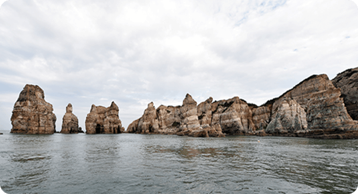
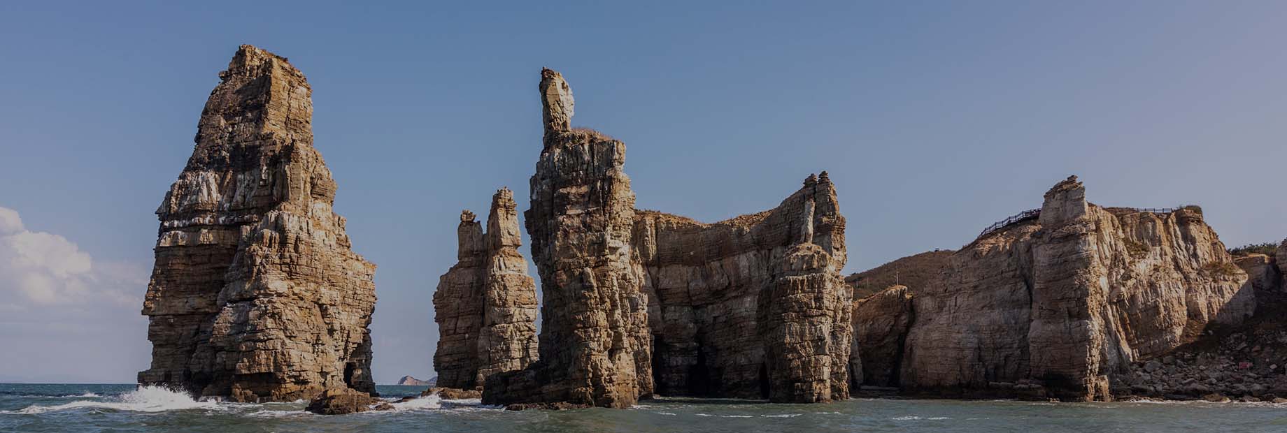
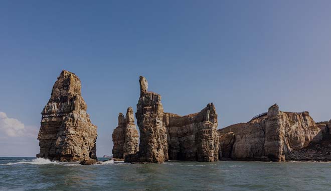
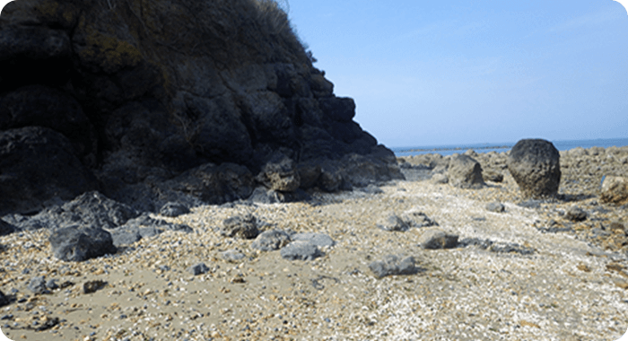
Dumujin
Dumujin, named for its resemblance to a gathering ofgenerals,
is celebrated as the "Haegeum River of the
West Sea" because of
its remarkable and unique rock
formations. It is primarily composed
of sandstones
formed through the gradual solidification of sand
deposited in shallow seas over 950 million years ago.
The surface
of Dumujin showcases notable geological
features such as cross-
bedding and ripple marks, which
offer insights to the tidal currents
during deposition.
The shape of Dumujin has been sculpted by
faulting
activities and the weathering and erosion processes
that
have occurred in the region over millions of years.
•Formation Process
- 1.
The sands moved from the land keeps accumulating
in shallow waters, forming sand beds.
Depending
on the directions of wind and tides, the power that
moved these sands, sloping layers are created inside. - 2.
As more sands build up and get compacted, clay
minerals around the grains act as a natural glue,
binding them together. - 3.
Over time, this compacted and solidified sand
becomes sandstone, mainly made of quartz. - 4.
Faulting activities in the area create many
cracks in the sandstone. - 5.
As the sea level of the area that used to be the
shallow sea gradually drops, the sandstone is
exposed to the surface of the sea.
The upper
layers are gradually worn away by weathering and erosion, leaving only the hardened
sandstone in the lower layers. - 6.
Cracks made by previous faulting activities
are more prone to weathering and erosion
and tend to disappear quickly. - 7.
Cracks in headlands gradually erode inward,
forming sea caves. - 8.
The upper parts of these sea caves gradually
collapse and expand, and these sea caves eroding
inward eventually pierce the opposite side, forming
sea arches. - 9.
Continued erosion causes the celling of the sea
arch to collapse further. When the top completely
erodes, a sea pillar is formed.
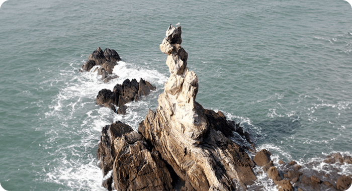
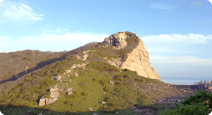
Yongteurimbawi Rock
Yongteurimbawi Rock is a uniquely shaped seapillar located on the
sea in front of the coastal cliffs
of Jangchon Village on Baengnyeongdo
Island.
It resembles a dragon twisting and ascending to heaven.
This
sea pillar was formed through the gradual
weathering and erosion of
a crack in the middle of a
protruding section of land. While most sea
pillars are
typically upright, Yongteurimbawi Rock stands out for
its
distinctive serpentine shape.
•Formation Process
- 1.
A crack forms in the landward portion of
a shoreline protruding into the ocean direction. - 2.
Over time, the crack gradually widens and deepens
due to the erosive forces of wind and waves, forming
sea caves. - 3.
Continued erosion deepens the hole until it breaches
through the opposite side, forming a sea arch. - 4.
As erosion continues, the ceiling of the sea arch
gradually collapses, leaving behind a sea pillar
detached from the land.
Jinchon-ri Basalt
The Jinchon-ri basalt, which is the same rock as Jeju Island,was created when mafic magma (magma high in iron and
magnesium and low in silicon) created
at the boundary
between the crust
and the mantle breached the crust and erupted
onto the
surface.Upon closer examination of the Jinchon-ri basalt,
greenish-colored grains embedded within it can be
observed, known
as olivine. Olivine is one of rocks
composing the mantle beneath the
Earth's crust
and helps us study material transformations and the
environment within the Earth. When the impurities of
olivine is low
and its transparency is high, it is used as
a gemstone called peridot.
•Formation Process
- 1.
Deep underground, at the boundary between the
crust and mantle, magma is formed as the crust
melts due to heat from mantle plumes. - 2.
The chemical composition of magma at the bottom
of the Earth's crust, rich in iron and magnesium,
gives it a lower specific gravity than the surrounding
rocks, causing it to rise. Additionally, it exhibits
relatively high viscosity. - 3.
As the magma rises, its lower specific gravity
causes it to carry fragments of the mantle rock,
olivine, along with it. - 4.
Upon reaching the surface, the magma erupts,
flows, and begins to cool rapidly in the atmosphere. - 5.
The magma solidifies into black basalt,
with scattered olivine crystals embedded within it.
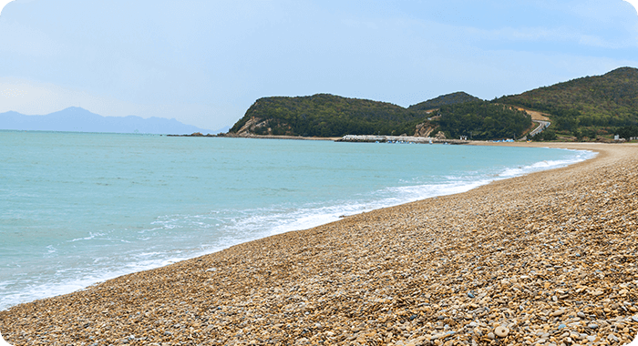
Kongdol Pebble Beach
Kongdol Pebble Beach stretches 1 km along thesouthern shore of
Baengnyeongdo Island. It features
rounded pebbles ranging from
5 mm to 15 cm in size.
These pebbles are formed after the island's
rocks
(quartzite, mudstone, sandstone, basalt, etc.) are broken
via
weathering and erosion, with waves continuously
rolling and smoothing
them over time.The pebbles at
Kongdol Beach are composed of rock
formations native
to Baengnyeongdo Island. Their rainbow colors and
concentrated presence along this coastline create a
unique and
striking coastal landscape.
•Formation Process
- 1.
The rocks surrounding Kongdol Pebble Beach
undergo weathering and erosion, gradually
breaking into fragments. - 2.
These rock fragments are then tumbled by ocean
currents, smoothing out their angular and protruding
shapes over time. - 3.
As they continue to be worn down, smaller
pieces are carried by currents and waves to
Kongdol Pebble Beach. - 4.
The waves push these pieces collected in Kongdol
Pebble Beach landward, where they accumulate
and pile up over time.
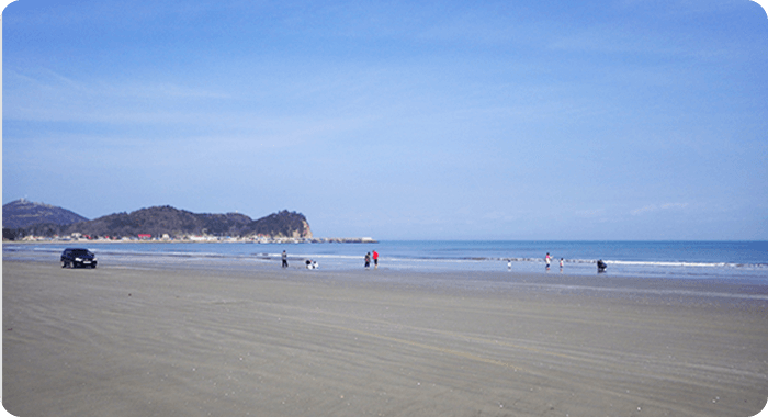
Sagot Beach
Sagot Beach features a very flat landscape with a2-kilometer-long
and 200-meter-wide white sandy
beach appearing at low tide.
It used to form a promontory
until a drainage gate and reclamation
project altered its
southwest side. Afterward, it was named Sagot
due to its
sandy appearance. Today, Sagot Beach is connected to
the opposite side by a drainage gate and no longer forms
a promontory.
The sand grains here are primarily angular
and measure about 200
to 250 micrometers in size.
While mainly composed of quartz, they
also contain
feldspar and olivine. The relatively high feldspar content
compared to the rocks on Baengnyeongdo Island
suggests an external
origin. The dating results further
indicate a different dating pattern
from the island's rocks,
supporting this conclusion. The beach's very
flat slope
allows seawater to fill the gaps between grains during
low
tide, giving it a relatively firm texture. This unique
feature of Sagot
Beach led to its use as an emergency
runway during the Korean War,
with aircraft operations
continuing until the 1980s. It remains a natural
airfield,
designated with airport identifier K-53 (RKSE).
•Formation Process
- 1.
Sand particles suspended in seawater are
transported to Sagot Beach by currents and waves. - 2.
A shoreline with a gentle slope far from land
experiences a rapid influx of water during high tide. - 3.
During tidal movements, waves carry sand towards
the shore. The weaker force of the receding waves
prevents the sand from being washed back out to
sea, causing it to settle. - 4.
As the tide recedes during low tide,
water retreats rapidly towards the ocean, though
the actual surface water level is not significant. - 5.
Water that seeps under the beach struggles to
drain effectively due to the insufficient height of the
water table, allowing the beach to remain stationary
between the sand particles. - 6.
The seawater between the grains of sand pushes
back with a force equivalent to the pressure applied
to the beach, thus supporting a firm beach structure.
Daecheongdo Island
Nongyeo Beach and Mia Beach
Nongyeo Beach and Mia Beach have wide white sandbeach at low
tide and are perfect spots for some dreamy
strolls with amazing wide
seascapes. Naitebawi Rock
stands on the edge of Nongyeo Beach
vertically where
some of the curved strata are left while others
disappear
due to folding, creating a singular landscape.
From Naitebawi Rock, facing Baengnyeongdo Island,
a sandbar has
existed from Mia Beach back to Okjuk-po,
and local residents say
that with each passing year, the
sandbar will continue to be gradually
longer and eventually
reach Baengnyeongdo Island. The south side
of Nongyeo
Beach is connected to Mia Beach, where wind and waves
drew ripple patterns on its white sand beach. The same
wave patterns
have been carved on the surface of
Yeonheunbawi Rock, huge cliff
in the white sand beach.
These well-preserved wave patterns date
back to the
formation of Daecheongdo Island 950 million years ago,
embodying an enduring natural phenomenon covering up
to billions
of years.
•Formation Process
- 1.
Sands and muds are constantly piled by turns
depending on the sea level change in a place
at some distance away from the ocean coast. - 2.
In due course, piled-up sands and muds become
compressed and hardened into sandstone and
mudstone respectively. - 3.
The strata composed of sandstone and mudstone
are bent due to a lateral pressure, leading to
vertical slope formation. - 4.
The strata with vertical slopes are uplifted
and weathering erosion begins. - 5.
As the faults and fissures occur, the current
Naitebawi Rock is created after the forms change
in order of sea caves, sea arches, and sea columns.
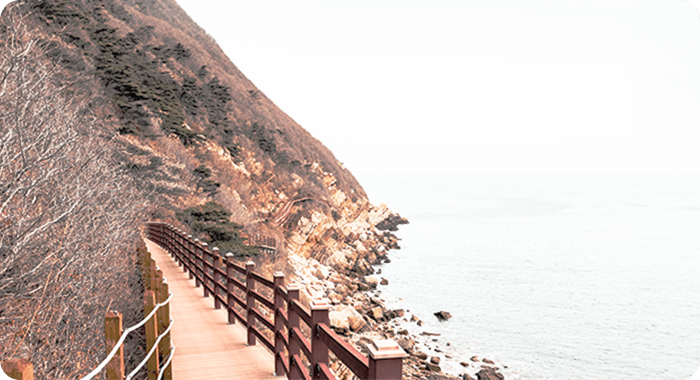
Seopungbaji Cliff
Seopungbaji Cliff rises nearly 80 meters high, presentinga magnificent vertical view composed entirely of white
sandstone.
Due to the prevailing westerlies blowing
from the west it is positioned
to face, the cliff scarcely
has vegetation growth, resulting in sparse
vegetation.
In contrast, the eastern gradual slopes, sheltered from
these winds, are densely vegetated. Viewing eastward
from
Seopungbaji Cliff towards Gireumagari Cliff across
the bay offers an i
ntriguing perspective on the gradual
changes of the slope of strata.
•Formation Process
- 1.
Sand continues to be accumulated
in the ocean near the coastal areas. - 2.
The accumulated sand lithifies over time
and becomes sandstone. - 3.
Greatly increased lateral pressure is applied to
the places where sandstones are deposited. - 4.
The strata are gradually bent laterally
under this intense lateral pressure. - 5.
As faults or fissures occurs, the western
and southern sides of Seopungbaji Cliff fall out
via weathering and erosion, creating cliffs.
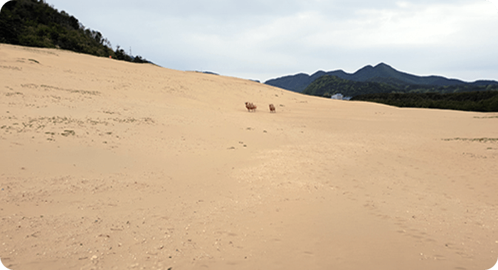
Okjuk-dong Coastal Dune
A coastal dune refers to a sand dune piled behindthe beach when
sands in the ocean are blown by wind.
Okjuk-dong Coastal Dune,
once spanning an area
equivalent to 60 soccer fields, is among
Republic of Korea's
largest coastal dunes. Currently, its size has been reduced
significantly because of the planting of a windbreak forest.
Previously, the activity of the sands was so active
that they could
reach up to Dap-dong Sports Complex
opposite Seonjin-po.
However, the construction of
the forest has considerably reduced
this activity.
Various dune creatures flourish in the Okjuk-dong Coastal
Dune, including sea wheatgrass, sedges, and
antlions during the rainy
season.
The surface of the dunes is often rippled by the wind,
In winter, when the wind is strong, the sand flowing can be observed.
•Formation Process
- 1.
The sand carried with the ocean's water
is deposited on the beach. - 2.
The sand deposited in the ocean
is moved inland by the wind. - 3.
When the sand encounters an obstacle, such
as a plant while traveling, it piles up in its place. - 4.
As time goes by, piled-up sand keeps
accumulating to form a dune.
Geomeunnang
Geomeunnang, meaning "black cliff," is a word usedwhen local
residents call this place as it stretches about
1.5 km along the coast
from the Dap-dong Sports
Complex on Daecheongdo Island to the
east. It has many
dark rocks in contrast to other places. All these
rocks in
Geomeunnang are sedimentary rocks unlike volcanic
rocks
like basalt in Jinchon-ri, Baengnyeongdo Island.
Geomeunnang's
sedimentary rocks are composed of
yellowish sandstone and
black mudstone. The reason
why the color of mudstone is black is
because the color
of minerals like biotite or chlorite is dark.
Most of
Geomeunnang's rock strata stand nearly vertical,
while in some
places inversions can be observed where
the upper part of strata
lies below its lower part.
Sometimes, cross-bedding can be seen
on the vertical
faces of the strata, while ripple marks appear on the
bedding planes sometimes. Also, unlike on
Baengnyeongdo Island,
where the strata lie horizontally,
here they stand vertically, and, the
mudstones have
many wavy folds unlike sandstones. It is because,
unlike
sandstones mostly composed
of quartz highly resistant to
physical change, the mudstones are primarily composed
of clay
minerals, which are much more ductile and tend
to be bent easily
under outside physical pressure.
•Formation Process
- 1.
Sand and mud are deposited in the place slightly
away from the shore depending on sea level changes. - 2.
The sand and mud deposited are hardened
into sandstone and mudstone, respectively. - 3.
The sandstone and mudstone are gradually bent by
the lateral pressure acting upon the point at which
they were deposited. - 4.
The slope of bent strata is deformed to a near
vertical shape. - 5.
The hard sandstone undergoes lesser bending,
but the more folds appear in ductile mudstone.
Socheongdo Island
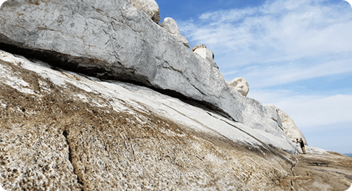
Bunbawi Rock and Woltti
Bunbawi Rock, composed of striking white marbleson Socheongdo
Island, got its name from locals who
compared its pristine whiteness
to a freshly painted
surface. On moonlit nights, the rock is surrounded
by
a distinctive white band visible from the sea, earning it
the nickname
'Woltti' (band of moonlight), and it serves
as a natural lighthouse.
Originally formed from limestone,
Bunbawi Rock is composed of the
remains of coral-like
organisms that thrived in Earth's ancient warm
oceans.
Over time, some of the limestone underwent
metamorphosis,
transforming into marble. Bunbawi Rock
is particularly notable for
containing stromatolite fossils,
which are the remnants of the
activities of blue-green
algae (cyanobacteria). These organisms
played a crucial
role in Earth's early oxygenation through
photosynthesis.
Locally referred to as 'Gulttakjidol Stone,' these
stromatolites are recognized as Republic of Korea's oldest fossils.
•Formation Process
- 1.
Coral reefs thrive in warm seas.
- 2.
When the coral reefs die, their tissues break down
and accumulate on the seafloor. - 3.
These remains eventually harden into limestone.
- 4.
Cyanobacteria photosynthesize in warm, shallow
seas and produce byproducts. - 5.
The byproducts accumulate in a fan-shaped
pattern. - 6.
Over time, these byproducts harden and become
fossils.
- Baengnyeong-Daecheong Geopark
- TEL 032-440-7884
- E-MAIL handa2325@korea.kr
- Address The Baengnyeong-Daecheong National Geopark, Baengnyeong-myeon, Daecheong-myeon, Ongjin-gun, Incheon, Republic of Korea


